A Browser for the FPV Drone-Strike Dataset
A few weeks ago I opened up a dataset of Hezbollah FPV drone-strike videos — every clip I could pull out of OSINT, labelled and kept in one place so anyone building a defense could start from real footage instead of a press release. It worked as a dataset: a repo, a manifest, download links, files in S3. It was miserable as something to actually look at. To answer a simple question — "show me the strikes on air-defense sites near the border, and skip the propaganda intros" — you were downloading MP4s and scrubbing through them by hand.
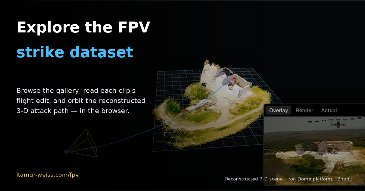
So I built the thing that was missing: a viewer that turns the folder-of-links into something you can browse, read, and fly through, right in the browser. It's live at itamar-weiss.com/fpv. This post is what it does and the two ideas behind it that I think are worth stealing for any video-forensics collection.
Three ways to look at the same clip
The viewer is small on purpose — one dataset, three views, each answering a different question.
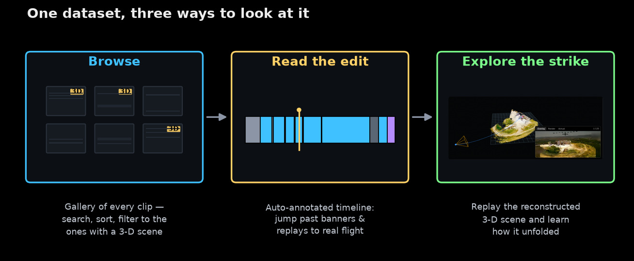
The gallery is the front door: every clip as a card with a first-frame thumbnail, searchable by description, town or date, sortable, and filterable down to just the ones that have a reconstructed 3-D scene. The player adds a flight-annotation timeline underneath the video. And the scene view — for the clips I've reconstructed — lets you orbit the actual 3-D geometry of the strike and measure distances in it.
Here's the whole thing in one pass — browsing the gallery, reading a clip's flight-annotated player, and orbiting its reconstructed 3-D scene (the strike on the "Biranit" Iron Dome platform):
It's the same catalog as the repo, just alive — and it grows as new footage surfaces. It's best experienced full-screen at itamar-weiss.com/fpv.
The clips are propaganda, so I annotate them
Here's the first idea that shaped the tool. These videos are edited — they're published as propaganda, not as evidence. A single clip opens on a title-card banner, cuts between flight segments, freezes on the moment of impact, and ends on a slow-motion replay with a branded outro. If you're a human trying to study tactics, or a model trying to learn from the footage, most of the runtime is noise the editor added on top. The camera is the weapon's eye, but only for part of the clip.
So every video in the viewer gets a flight-annotation timeline: the footage is segmented into flight, banner, pause / freeze and replay, and the player lets you jump straight to the parts that are genuinely the drone flying. Here's one clip, annotated — the 2026-06-06 Merkava-tank strike near Blat:
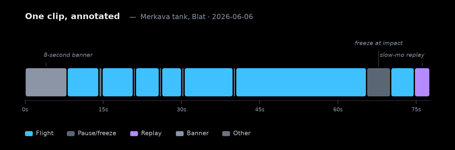
You can read the edit right off the ribbon: an eight-second banner up front, a burst of flight segments broken up by brief freeze-frames as the editor punches in on targets, a longer pause near the moment of impact, and a replay tail at the end. The blue is the only part that's actually a camera moving through the world.
And this isn't a one-off. Once every clip is annotated, you can add it up across the whole dataset — and the split is its own small piece of intelligence:
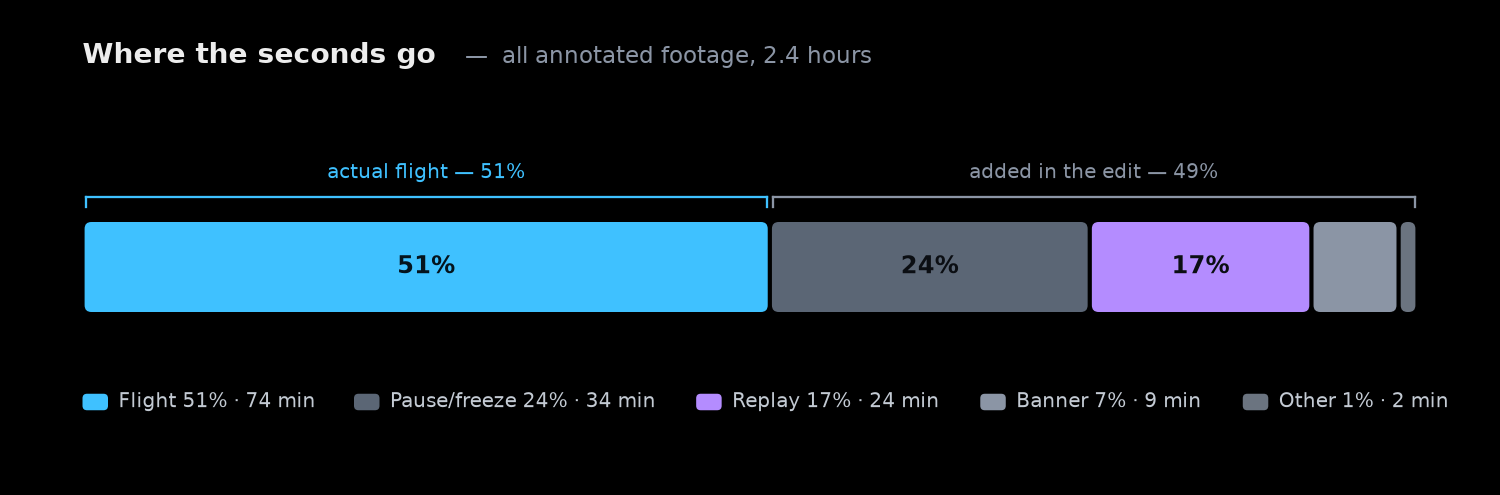
Of the roughly 2.4 hours of annotated footage, only about half is real flight. The other half is banners, freeze-frames and replays. That's the concrete argument for annotating: if you feed a reconstruction pipeline or a training set the raw clips, half your data is title cards and slow-motion — and, worse, the freezes and replays look like camera motion to a naive algorithm and quietly poison the geometry. The timeline is how you keep only the signal. (The segment boundaries here are auto-generated; they're a starting point, not hand-verified ground truth.)
The clips you can fly
The second idea is the payoff from the last post, made interactive. There I took a single clip and recovered the drone's real 3-D attack path straight from the pixels — no telemetry, just VGGT run over the isolated flight frames. Since then I've run that pipeline across the dataset, and a growing share of the clips now have a full 3-D reconstruction you can open in the browser.
Each scene is the recovered point cloud of the terrain plus the drone's flight path — the ordered camera centers — drawn from the launch camera along the approach to the terminal pose over the target, with a corner panel that plays the real footage in step with the reconstruction. You orbit it with the mouse, and there's a measure tool: click two points and it reads back the distance between them, so you can eyeball a standoff range or the size of a targeted vehicle in the reconstruction's own units. Filter the gallery to 3D scenes and click any card's 3D scene button to open one.
Do that across the whole collection and the anecdotes start turning into distributions: approach corridors, dive angles, standoff distances — the geometry of how these attacks actually unfold, browsable one clip at a time.
Why bother building the viewer
I could have left it as a repo. But a dataset you can't see barely gets used, and the whole reason I opened this one up was for it to get used — by anyone trying to understand how the threat behaves, or to build and evaluate the sensors and algorithms that stop it. It's the same instinct behind designing a microphone array to hear these drones: the tools only get you so far without representative data you can actually put your hands on.
So the viewer is live and it tracks the dataset as it grows: itamar-weiss.com/fpv. The underlying collection — clips, labels, manifest — stays open at github.com/itamarwe/fpv-drone-strikes-lebanon-dataset. Browse it, learn from it, and if you have footage that belongs in it, send it my way.